


 |
|
|---|---|
 |
Jammu & Kashmir |
 |
|
 |
J & K |
 |
|
 |
|
 |
Directors |


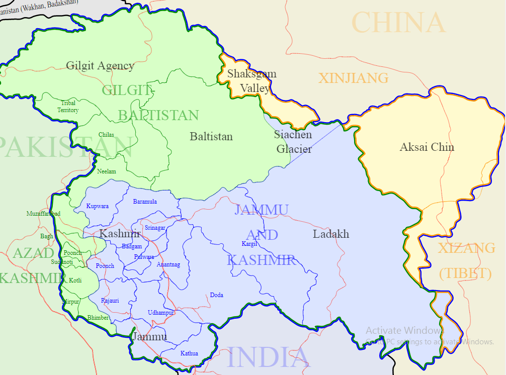
Kashmir (Kashmiri: کٔشِیر, कॅशीर; Urdu: کشمیر) is the northwestern region of the Indian subcontinent. The Kashmir Valley is a valley in the portion of the Kashmir region administered by India. The valley is bounded on the southwest by the Pir Panjal Range and on the northeast by the main Himalayas range. It is approximately 135 km long and 32 km wide, and is drained by the Jhelum River.
Kashmir division is one of the three administrative divisions of the Indian state of Jammu and Kashmir. The Kashmir division borders Jammu Division to the south and Ladakh to the east while Line of Control forms its northern and the western border. The division consists of the following districts: Anantnag, Baramulla, Budgam, Bandipore, Ganderbal, Kupwara, Kulgam, Pulwama, Shopian and Srinagar.
Ladakh ("land of high passes") (Ladakhi: ལ་དྭགས la'dwags; Hindi: लद्दाख़ laddākh; Urdu: لَدّاخ ) is a region in Indian state of Jammu and Kashmir that currently extends from the Kunlun mountain range to the main Great Himalayas to the south, inhabited by people of Indo-Aryan and Tibetan descent. It is one of the most sparsely populated regions in Jammu and Kashmir and its culture and history are closely related to that of Tibet.
Source: https://en.wikipedia.org/
|
Source: http://www.census2011.co.in/
Geography:
Jammu and Kashmir location is between 32.17" and 36.58" North altitude and East to West, the State lies between 73.26" and 80.30" longitude. In case of latitude, Jammu and Kashmir matches up with South Carolina (North America), Fez (Morracco), Damascus, Baghdad and Peshawar (Pakistan). The standard time in Kashmir is 5.30 hours ahead of Greenwich Mean Time (GMT) and has a difference of half an hour with the local time.
Kashmir Valley has a moderate climate, which is largely defined by its geographic location, with the towering Karakoram Range in the north, Pir Panjal Range in the south and west and Zanskar Range in the east. It can be generally described as cool in the spring and autumn, mild in the summer and cold in the winter
Compared with other plain parts of India, Kashmir valley enjoys a more moderate climate but weather conditions are unpredictable. The recorded high temperature is 33 °C and the recorded low is −18 °C.
Ladakh is the highest plateau in the state of Jammu & Kashmir with much of it being over 3,000 m (9,800 ft).It extends from the Himalayan to the Kunlun Ranges and includes the upper Indus River valley. Ladakh is a high altitude desert as the Himalayas create a rain shadow, generally denying entry to monsoon clouds. The main source of water is the winter snowfall on the mountains. . Summers are short, though they are long enough to grow crops. The summer weather is dry and pleasant. Temperature ranges are from 3 to 35 °C in summer and minimums range from -20 to -35 °C in winter
Source: https://en.wikipedia.org/
Jammu and Kashmir has population of 1.25 Crores, an increase from figure of 1.01 Crore in 2001 census. Total population of Jammu and Kashmir as per 2011 census is 12,541,302 of which male and female are 6,640,662 and 5,900,640 respectively. In 2001, total population was 10,143,700 in which males were 5,360,926 while females were 4,782,774.
The total population growth in this decade was 23.64 percent while in previous decade it was 29.04 percent. The population of Jammu and Kashmir forms 1.04 percent of India in 2011. In 2001, the figure was 0.99 percent.

Kashmir : The major ethnic group of Kashmir Valley are Kashmiris and they speak the Kashmiri language. Smaller ethno-linguistic groups include the Gujjars and Bakarwals who mostly live along mountain ranges of the valley. The valley has a Muslim majority population and Islam is practiced by 97.16% of the population with the remaining being Hindus (1.84%), Sikhs (0.88%), Buddhists (0.11%) and others. The principal spoken languages in the valley are Kashmiri and Urdu, with Urdu being the official language. Many speakers of these languages also know English as a second language.
Ladakh: People of Dard descent predominate in Dras and Dha-Hanu areas. The residents of the Dha-Hanu area, known as Brokpa, are followers of Tibetan Buddhism and have preserved much of their original Dardic traditions and customs. The Dards of Dras, however, have converted to Islam and have been strongly influenced by their Kashmiri neighbours. The Mons are believed to be descendants of earlier Indian settlers in Ladakh, and traditionally worked as musicians, blacksmiths and carpenters. The region's population is split roughly in half between the districts of Leh and Kargil. 76.87% population of Kargil is Muslim, while that of Leh is 66.40% Buddhist as per the 2011 census.
Source: https://en.wikipedia.org/
Health sector:
Infrastructure:
Number of Health Institutions in Kashmir and Ladakh Divisions:
Category |
Total |
Hospitals |
|
District Hospital |
9 |
Emergency Hospital/AH/Trauma |
2 |
Sub District Hospital SDH / CHC |
50 |
Primary Health Centre PHC / MMC |
232 |
New Type PHC |
325 |
District TB Centers / Laper |
8 |
Urban Health Centre/ Evening Clinics |
2 |
Mobile Medical AID Centre |
6 |
Sub Centers |
1468 |
Training schools |
|
General Nursing and Midwifery Schools |
6 |
Auxiliary Nursing and Midwifery Schools |
7 |
Skill lab |
3 |
Simulation Lab |
1 |
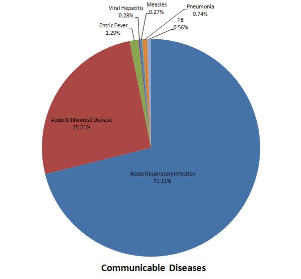
Graphical representation of Communicable diseases in Kashmir and Ladakh Region (2016-17)
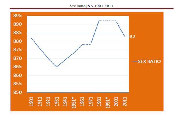
Graphical representation of changing Sex Ratio in Jammu and Kashmir from 1901 to 2011:
Source: http://www.censusindia.gov.in/